Day 2 Pendeen to St Ives 14 Miles

http://my.viewranger.com/track/widget/1986773?locale=en&m=miles

I woke up at sixish and I was ready to go by seven fifteen. The wind was still fierce but manageable, my wonderful tent had survived the night. I suspect at some point on this trip it will break or tear, it’ll  be like losing a friend.

Cliff edge near Zennor Head

Made my way across the fields back to the shore line, my heart already sinking as I could see my path descending to the sea before crossing a steam and going straight back up. Still with the eagerness of someone only on her second day I marched on. The climb left be gasping, I’m just not fit enough for them and I was forced to stop a number of times, pretending to enjoy the view and watching out for any other hikers who might shame me.

The weather was forever changing as rain clouds were blown through, after the downfall the sun and wind drying everything quickly. The more tired I got the more the wind became a nuisance , knocking me off balance continually. If nothing else the day showed just how ridiculous people that climb Everest and the Eiga are.
Anyway back to the complaining. The entire day consists of descending into galleys and the climbing out. Great views but hard terrain and no change to get a rhythm. I was comforted to discover that the guide book considers this section one of the toughest of the Southwest Coastal Path, so maybe I’m not such a wimp after all.

I did enjoy some of the views, although usually the ones across a short flat patch, mainly I found it all frustrating. The Pennine Way has hard climbs, larger than today’s but after an hour or two of hard walking your on top, so you take your medicine and soldier down. There’s none of this up down up down up down thing. Bloody nature.
It took nearly then hours to get to St Ives, my walking pace mostly 3km an hour. There was one section where I felt completely stuck. Massive boulders blocked the track. Without a backpack it might have been fun but while carrying 19 KG it was no picnic.
I ducked gratefully inland at River Cover and walked the last three or four miles across the fields. It was wonderful. I suddenly found I could walk again. My legs felt like led while climbing but on the flat they were fine. I past Trevalgan touring park (who’d kindly offered me a free pitch in support of the charity) and walked on to Ayr Campsite. This one is a lot closer to the town,  overlooking the harbor about fifteen minutes from the center.
It’s a wonderful campsite. Special area for backpackers, great shower rooms and toilets and cafe with a pool and lounging rooms. Everything is cared for and warm. The staff were friendly and even the wind couldn’t stop it from been a very cosy night.

Ayr Campsite looking over St Ives

Popped into the town to buy a few snacks for tomorrow, and something healthy for dinner- ended up with chips from a Fish and chip shop called the Albatross. Gentleman who served me did however sponsor me £5. I think I might walk inland tomorrow and avoid the coast as much as I can.

Day 1 – Land End to Pendeen 10 Miles

http://my.viewranger.com/track/widget/1618212?locale=en&m=miles

Crossing the river Tamar to Cornwall on the train

I got to Plymouth at 5:15 and rushed across town to catch my 5:45 train to Penzance. Light was starting to seep across the city centre. The people I past were a mixture of those drifting along who’d woken up early for work and those who’d yet to go to sleep. I walked the first ten minutes with my shoelaces undone from the coach, sure I’d miss the train. I’d reserved advanced tickets, and I still needed to pick them up at the station before boarding. After nearly missing my megabus from London I was waiting for something else to go wrong. The idea that I was actually starting was staggering, I really couldn’t get my head around it. I’d not trained enough, I’d gone on one over night walk and was in general unfit. This was ridiculous.
Everything, however, went fine and I found myself on a charmingly retro train with wide arm chair style seats and sleeper compartments. While it seemed to travel incredibly slowly it was also wonderfully smooth and I dozed happily. Compared with the cramped knee crushing chairs in megabus these coaches were heaven.

View from Penzance Train station back to St Michael’s Mount

Once at Penzance I searched for a cafe to have breakfast in while waiting for the bus. Straight outside the station is a wonderfully cheap and friendly greasy spoon called Sullivan’s Dinner. Fried egg sandwiches £1.20 and tea for £1. It’s not a stylish buildings, rather a rundown box but the foods good and quick.
  I could feel my heart beating a little faster on the bus. I couldn’t help fidget and check the straps on the backpack as if they’d suddenly break. Its a state of the art Deuter backpack, the straps are not going to break anytime soon. Although only a dozen or so miles away the bus was slow and wound around the town in zigzags taking nearly 50 minutes to complete the journey.
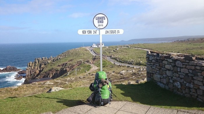
  Lands end was crowded with tourists, a large group of cyclists near the entrance balanced on their perches listening to their leaders instructions. Most of the people milling around were foreigner. I wondered past them feeling fooling with my backpack. I found a smaller sign than I’d expected and got a nice gentleman to take some pics of me grinning. I tried to hold up the banner but the wind wouldn’t let me. A weather warning had been issued for today’s winds and they were spot on.
Once I’d registered for the walk, had a toilet break, I finally set off. Walkers were everywhere, but none wearing the backpack and I stood out horribly. This became less conspicuous as I left Cowle and dropped down to Whitesand Bay.
The walking isn’t too steep but once off the beach the path is hard under foot, a few scrambles slowing me down and breaking my rhythm. Longer distance walkers wondered past here and there, more than I’ve ever seen. I seemed to have finally planned a walk during the hiking season.

Registration book at the start of Land’s End to John o’Groats
Freswick Beech

  It took quite a while to reach Cape Cornwall. Chimneys begin to speckle the landscape like silent wardens. Tin mining is evident but not in an ugly way, time making their ruins romantic. The idea of the labyrinth beneath my feet adds mystery to their shapes.
My new hat proved a major success, fitting perfectly and keeping the hair out of my face. I also figured I should get used to wearing it before the summer really begins.
Cutting across farm land I reached Pendeen and found North Inn where I camped. The wind was so strong I was seriously worried for my tent and spent nearly half an hour fastening it down. Even now sat in the pub I’m a little worried I’ll go back to find it gone. That would not be a good start. 


Showered I made myself dinner, couscous and tinned diced and beef in gravy. Dull food and a mistake. Also the tin cost £3 which is a tad pricy. If I get to St Ives early enough I’ll find a proper shop and do better. I’ve also promised myself a pasty before leaving Cornwall so that is also on the menu.
Only 13 miles tomorrow so another relatively easy day, and a chance to allow my body to adapt to the trail. First day done I feel slightly less scared, still don’t believe I’m actually doing though.

North Inn Campsite, Pendeen
https://www.givey.com/c/girlgoeshiking
Painting of the walker with body measurements along her figure.

Land’s End to John o’Groats! Ready? Steady? ….WHAT DO YOU MEAN YOUR NOT READY?!

I’m on my way. I’vPainting of the walker with body measurements along her figure.e been sat on the coach now for the last next fifteen hours as I’m making my way down to Lands End. Judging from my sniffling as I watched a feel good film on my phone I’m more nervous than I’m letting on. It was good to have a few hours in London with some mates before catching the second coach to Plymouth. Might be a long winded journey but at nearly a hundred pounds cheaper than the train I wasn’t going to be too fussy. As it’s going to take me well over a month to make my way back I also need to stop thinking of time as an issue.

There’s been a weather warning issued in Cornwall for severe winds at the start of this week. Not a lot of rain but could be an interesting start to the trail.

Last night I packed one last time, listing everything and been as ruthless as I could possibly be. Charged all electronic and failed to sleep. I also used a tape measure to record my measurements, a before and after well let me know the affects the walk will have had on my body. I still feel like a fraud and am terrified of failing now that the charity is set up and depending on me. Fitness wise I’ve failed, hardly having gone on any walks before and ignoring my gym membership. Some of the guides go into some depth on different ways of training, a hiker stated on his blog that he walked two 30 mile day hikes every week for the three months preceding the walk. I walked the ten minutes to work everyday… Well too late to worry about it now.  Perhaps I could be a poster child for slightly obese people getting outdoors, whats the campaign called? Britain on Foot!

As I’m also a painter, and worked on a piece about body image, I added my measurements on top. After the walk I will measure myself again and see if there’s a change.

Body measurements before the walk overlaid on my painting ‘Taking Measure’